Tag Archives: maps

Dogs of war – or peace?⤴

from

Today’s Daily Create asks us to

Try this site that gives you a bit of control over world maps. It allows you to re-orientate the world map to specific countries (so you change the common perspective found in so many maps).

You have a few different map types to play with, too. Maybe you make a political statement? Or maybe you just make some art!

I clicked on the UK, and the resulting map reminded me of two big, friendly dogs saying hello to each other. so I loaded up SmoothDraw and did a tiny bit of doodling:

Dogs of war - or peace?
Dogs of war – or peace? flickr photo by NomadWarMachine shared under a Creative Commons (CC BY-NC-SA 4.0) license

Dogs of war, or dogs or peace? Who decides?

Life in Links 63⤴

from @ wwwd – John's World Wide Wall Display

montage of six webpages listed in article

Craig Mod on The Talk Show

Interesting take on the morality of using AI

But I have a hard time parsing out what is moral or amoral about how this stuff is being used, or how the information’s been gleaned, or whatever it’s been sucked up from.

-✂️ snip-

00:03:25 ◼ ► I don’t use any of the photo generation crap or whatever.

00:03:28 ◼ ► What I do think is profound, and I feel like it’s way more morally defensible, is the code generation stuff, just because of all the open source stuff, yada, yada

The Talk Show ✪: Ep. 421, With Craig Mod

The Sea

▶︎ The Sea | Francisco del Pino/Charlotte Mundy | Notice Recordings


wilding.radio

From the famous Knapp estate via Joe

we have installed a solar-powered, quadrophonic live audio feed just north of the dam: A pair of hydrophones brings us closer to the sounds of the water itself and reveals the tiny sounds of fresh-water organisms. A pair of microphones in a fallen willow tree let us get to know the birds and mammals that live near and visit the water and hear the play of weather in the trees.

wilding.radio

Organic Maps

I’ve installed this on my phone with the intention of giving it a shot for recording walks.

Organic Maps is a privacy-focused offline maps & GPS app for hiking, cycling, biking, and driving. Absolutely free. No ads. No tracking. Developed with love by the open-source community. Powered by OpenStreetMap data.

Organic Maps is one of the few applications nowadays that supports 100% of features without an active Internet connection. Install Organic Maps, download maps, throw away your SIM card, and go for a weeklong trip on a single battery charge without any byte sent to the network.

Organic Maps: Offline Hike, Bike, Trails and Navigation

Poetry on the line

Quite delightful raspberry pi project.

 a vintage phone brought to life with Raspberry Pi

Poetry on the line: a vintage phone brought to life with Raspberry Pi – Raspberry Pi

My ‘secret strings’ game to unlock ‘texts’ 

Looks like a good classroom activity.I’ve done similar occasionally but the prompt is much better than mine.

 You tell the children/students that they are going to be poem or story ‘detectives’ and their job is find the ‘secret strings’ in a poem or story – or play or any ‘text’.

Secret strings run within texts linking words, phrases, sentences and pictures or ‘images’. The students’ job is to find them. 

Sometimes the link is to do with sound – eg alliteration, assonance, rhythm, rhyme, repetition, long phrases, short phrases. 

Michael Rosen: My ‘secret strings’ game to unlock ‘texts’ (stories, poems, plays, non-fiction etc)

Augmented Reality in the Wild⤴

from @ wwwd – John's World Wide Wall Display

I’ve been using the PeakFinder app for a month or two now. It is a nice app for showing what hills are in view. Basically it give a ‘live’ wireframe of hilsl from your location or anywhere you like. All the features are listed PeakFinder App.

Today I opened the app and it must have been updated, because it gave me a message saying:

Augmented reality
For a long time many of you have asked for an option to combine the image of the camera with the panorama drawing. l’ve finally implemented this feature in this newest version and so PeakFinder now also supports true augmented reality.

This is quite amazing, and in my tests it works a treat.

I think this is the first AR I’ve seen that makes be think this could really be useful and soon. It is not much of a stretch to imagine a botany app that can recognise flowers.

What is cool about peakfinder is that the data is loaded so that you do not need a connection to use the application.

GPX Shrinking⤴

from @ John's World Wide Wall Display

walk-map

I occasionally make simple mashup of of gpx, google maps and flickr photos of walks. I record gpx on the Trails app on my phone, take photos with the phone too as they are nicely geo tagged and flickr  can use that information and provide in the API 1.

One of the things I noticed was that the GPX files can be pretty big, over a megabyte each. I know there was probably a lot of information in the file that was not needed to display the path on the map but was not sure of how to do so easily. I think I’ve used online services for this before. Finding a site, uploading a file and downloading is a lot of bother for something that I hope will be quick and simple. I also expect that the audience for the pages produced is one.

Having a look inside the gpx files I though that you could probably slim them down considerably, each point is recorded like this:

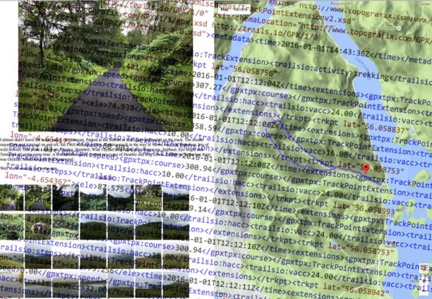
<trkpt lat="55.996687" lon="-4.389713"><ele>188.609</ele><time>2016-06-05T10:12:58Z</time><extensions><gpxtpx:TrackPointExtension><gpxtpx:speed>1.30</gpxtpx:speed><gpxtpx:course>206.37</gpxtpx:course></gpxtpx:TrackPointExtension><trailsio:TrackPointExtension><trailsio:hacc>5.00</trailsio:hacc><trailsio:vacc>3.00</trailsio:vacc><trailsio:steps>2</trailsio:steps></trailsio:TrackPointExtension></extensions></trkpt> 

I am pretty sure all we need is:
<trkpt lat="55.996687" lon="-4.389713"><ele>188.609</ele></trkpt>

and that a regular expression could do the trick.

I don’t know anything about RegEx other than I’ve found it offered as a solution when googling text replacement problems but this:

replace: <extensions>.?</extensions> with nothing
followed by replace: <time>.
?</time> with nothing

I am guessing I could combine these, but it din’t take long to run through a few files using them in this crude form.

Before After

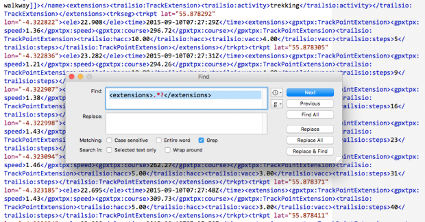
did the trick. My 1MB file was now 160KB

This works both in BBEdit and TextMate. TextMate struggled a bit with the size of the files.

This post will be of little interest to anyone but myself and might just fit in the suchlike bit of this blogs sub title.

Featured Image: two screenshots, layered. my own CC-BY.

1.
I’ve blogged about some of the methods I’ve used before.

Loch Oss & Ben Oss⤴

from @ John's World Wide Wall Display

IMG_2690 IMG_2691 IMG_2727 IMG_2767 IMG_2771 IMG_5362

I am testing the WP-OSM-Plugin I was hoping that the map would show the photos on markers as well as the GPX track I’ve uploaded. There is an example: EXIF-Test-page | WordPress OpenStreetMap Plugin

The shortcode I am using looks ok to me and the photos are geotagged. I added a fullsized one because the thumbnails are stripped of geo-tags. So I expected the one big photo t oshow up at least….

[osm_map_v3 map_center="56.379,-4.727" zoom="12" width="100%" height="450" file_list="/blog/wp-content/uploads/2015/08/been-oss-loch-oss.gpx" import="exif_m" marker_name="mic_black_camera_01.png"]


IMG_2690